Friday, September 30, 2011

California, Here We Come!

Mount Shasta in Northern California.
We have taken nine days to drive down from Canada to home.  We are not doing much sightseeing – we are saving Washington and Oregon for future trips.
The Peace Arch, as we crossed from Vancouver into Washington.
We did stay in the Tillamook, Oregon area for a day to tour the Tillamook Cheese Factory, see the Naval Air Museum which is housed in a WWII blimp hangar and to take a very nice quilt tour, where large quilt blocks are painted on historic barns throughout the area. We had dinner with my nephew, Mike Purcell, and his family and had a terrific visit.

My nephew, Mike Purcell, and his beautiful family.

Of course, we see lots of wildlife in Oregon (but not in Alaska) - a herd of elk near the Tillamook airport.

A home-built blimp at the Tillamook Air Museum.  The museum in housed in a WWII blimp hangar, made entirely of wood.

One of the quilt tour blocks.  The tour takes you on a very scenic drive through the Tillamook countryside. The dairy smells reminded me of my growing up days in Artesia.

Corrigan and his new friends enjoying their Tillamook ice cream inside a Tillamook loaf van.
We made our way from the Oregon coast to Sisters, Oregon on a windy, rainy day to visit a quilt shop which several of my quilting buddies said was a must see. And since we were on the east side of the Cascades, we stayed there and traveled down from Bend, Oregon through Klamath Falls into California. Glad we did since the weather improved significantly – clear and dry with highs in the 70s and 80s.  Haven’t seen that since a couple days we had in Fairbanks.
We stayed one day in the Mount Shasta area in order to see a niece of mine, Dawne Ramshaw, and her family.  Had a great dinner and visit with them.
My neice, Dawne Ramshaw, and her family (minus a daughter who is away at college). It was so good to see them and get caught up on news.

Mt. Shasta as seen from our campground at Lake Siskiyou.

A group of six deer including several fawns who still had their spots visited a spot near our campsite both afternoons that we were there.
It will be good to get back into the “old” routine, I think. But I wonder if I will miss the traveling, if I will be bored by the sameness of everyday life back in Long Beach.
We started this trip back on June 6th. One hundred and ten days later, we have traveled over 14,000 miles, stayed at about 40 campgrounds, taken three glacier cruises and one sternwheeler ride, toured too many museums and have seen a representative set of Alaskan critters. We replaced one tire and a bathroom sink. We drove almost every paved road in Alaska and over 350 miles of dirt/gravel roads. We are returning home with a broken kitchen drawer and a busted gas pipe in the oven.  Actually not bad, considering the condition of the roads we traveled.
A trip to Alaska has been a dream of mine since my twenties. Was it what I thought it would be?  Yes and no. The condition of the Alaska Highway is much better than I thought it would be, although it is much rougher than any of the roads I have been on in the lower 48. Traveling with a trailer is pretty convenient – your own kitchen, bathroom and bed whenever you need them.  And it is extremely comfy to sit in your warm, dry trailer while rain is pouring down outside.  Of course, getting out there to hook up your trailer for your next day’s travel isn’t too much fun, but Russ didn’t seem to mind. I thought we would spend more time relaxing at our various campsites, sitting around campfires and enjoying the scenery, but the cold temperatures, rain and the mosquitoes pretty much put an end to that most days. Traveling without deadlines or schedules is as freeing as I imagined it to be.
The size of Alaska is mindboggling. With all the miles we drove, we saw just a small fraction of the state. There are national parks you can get to only by small plane, boat or dogsled (and yes, dogsleds are used on a regular basis in this part of the country.) There are icefields larger than some states in the lower 48. And the number of really tall mountains and glaciers seems uncountable.
I find it impossible to describe the beauty and wildness of the Alaskan and Yukon scenery.  To stand on the Top of the World Highway and gaze on a seemingly endless string of forested mountain ridges with no evidence of any human presence other than the dirt road stretching in front of us …I found myself thanking God for the world He created and for giving me the opportunity to see it in this pristine form. When we toured the tidewater glaciers and saw some of the marine life up close, I found myself hoping that humankind can take heed and change behaviors to preserve the environment. We are all so interconnected with nature and we, for the most part, ignore that interdependency or just pay it token heed.
I highly recommend Alaska.  If you don’t have time to take four months and drive up there, then take a cruise, fly up and rent an RV for two weeks, or just rent a car and drive around.  Buy a Milepost book, get on the road, and go.  It is incredible.

Thursday, September 22, 2011

Super, Natural British Columbia!

Corrigan tried to hitch a ride with another tourist - but he decided our setup was a bit more comfortable.
Reached Cache Creek, British Columbia, after a day of rainy, very muddy driving through several construction areas where we were led by pilot cars.  Added about two hours onto the drive. By the time we got to Cache Creek, we were pooped.

Cache Creek area is very arid – started seeing sage brush and brown hills similar to what we see at home, except there were pines instead of California Oaks on the hillsides. This is cowboy country big time!  Lots of dude ranches, wooden corrals and grazing horses.
View of the Fraser River.


Tunnels for the Trans-Canada trains. 
Just south of Cache Creek, Cariboo Highway terminated into the Trans-Canada Highway.  Russ and his family had traveled the Trans-Canada many years ago on their way to the Seattle World's Fair.  Understandably, Russ didn't recognize any of the road. Stopped at Hell’s Gate in Fraser River Valley.  Very wild looking river and canyon area.  Took a very nice tram ride to the other side of the canyon and had one of the best burgers I’ve eaten on this whole trip.
Pay no attention to the woman with the crazy hair!  She has not been to her hairdresser for almost 4 months and the hair has taken on a life of its own.


View of Fraser River as we cross in the tram. The concrete formations are fish ladders which allow salmon to move upstream.
The tram descends about 500 feet from one side of the canyon to the other.

The obligatory gift shop, fudge shoppe and restaurant.


The Trans-Canada Highway is very twisty going through Fraser Canyon.
Our RV park is about 20 miles outside of Vancouver – a very quiet park with beautiful gardens.  Still a lot of agriculture in the area, mostly blueberries and sorghum. Made for about a 45 minute commute into the town, but the drive was very interesting. Decided to stay only four days since we will be coming back in the next year or two to take a cruise up the Inside Passage and we will do a more extensive tour of the area, including Victoria and Vancouver Island. I am very impressed with Vancouver and the people.  The city is very modern and clean.  The people are extremely polite (something we have also found elsewhere in Canada). They are very proud that they hosted the 2010 Winter Olympics and very embarrassed that riots occurred after the Stanley Cup finals. Did not know that the citizens came out in force to voluntarily clean up the aftermath – pretty impressive.
Outside the Vancouver Aquarium.


This serving bowl is about four feet long - the people really knew how to throw great buffets!

The Raven and the birth of the First People - the Haida.  Carved by a modern-day totem pole carver and artist, Bill Reid.

Dancing demonstration at the Museum of Anthropology.

An authentic Haida village with totems - outside the Museum of Anthropology.

The first Tibetan monastery built in North America.  Huge building!

On the same street as the monastery is an India cultural center.  There was also a muslim center, muslim secondary school, a Sikh temple and several Christian churches.

The convention centre and view of Vancouver's skyline.

Two cruise ships were in port the day we toured.

View of the Disney cruise ship and two seaplanes taking off. Heard the ship's whistle "When You Wish Upon a Star.." as it was leaving.

One of the many art sculptures throughout the city.

A clock run by steam.  Every fifteen minutes, it plays Westminster chimes.

The Olympic Flame. This was lit by Wayne Gretzky on opening night of the 2010 Winter Olympics.

A moth that looks like a decaying leaf, part of an exhibit on the Amazon at the Vancouver Aquarium.


These guys reminded me of Richard Scarry's worms.

This very large (about 3 feet across) sea turtle was rescued north of Vancouver after he ran out of the warm water stream he was swimming in.  Almost died of hypothermia.

A very pretty, poisonous frog.
We are heading south through Washington and Oregon.  Expect to be home the first week of October. I probably will do one more blog after this to wrap up this grand adventure.  Hard to believe it is almost over!

Thursday, September 15, 2011

Whoops! I Guess It's on To Plan B.

Beautiful Fall colors on the Alaska Highway headed south from Whitehorse, Yukon.
After two days in Whitehorse, we headed south back down the Alaska Highway. We were originally planning on taking the Cassier Highway (Hwy 37) south through British Columbia.  But it is closed for over 200 kilometers due to mudslides and flooding. So we went about 100 miles further east and took Highway 29 and Highway 97 south to Prince George. The fall colors are beautiful. We even saw some wildlife - elk, bison and a mother black bear with her three cubs.

Miles Canyon just south of Whitehorse. Before the river was dammed, the rapids in this canyon were almost impossible to cross. The stampeders had to pay to have their stuff portaged around the canyon.


On the Alaska Highway.

Wood Bison near Liard Hot Springs.


First night out of Whitehorse, we stayed at an RV park on the shores of Muncho Lake. The spot was beautiful with a very nice view of the lake.  That is, until a huge 5th wheeler pulled up in the adjacent campsite and completely blocked our view.  Then they opened their slideouts and we became VERY close neighbors.  The campsites were just too small for that size of RV. Sigh…
View of Muncho Lake from our campsite, before the monster 5th wheeler showed up.

The lake was smooth as glass when we left the next morning.

Elk on the highway.


We had been warned about the extreme dust clouds that could occur on the areas of the highway that were gravel, but this is the first time we really had the full experience.  Just like being in a thick fog.
 Third night out was even more interesting.  There are NO campgrounds between Fort Nelson and where we were turning south on Highway 29.  The provincial parks are closed (not that there were that many provincial parks anyway) and the few RV parks that existed are out of business.  We finally stopped at one place that was open but it was full.  They said that another hour down the road there was a campground at Wonowon. By this time, it was dark and I don’t like driving in the dark where there are wild critters (hit a deer in Michigan driving at night a few years ago….not fun). But we headed out.  Well…when we got to Wonowon, we found a gas station that had a convenience store and nothing else.  There hadn’t been a campground there for a very long time! They said that an hour down the road, there is a campground.  Now, where have we heard that before?  So they offered to let us pull over in the dirt lot next to the gas station for the night. We ended up boondocking (that is dry camping) for the night and it worked great!  A bit noisy, what with the trucks pulling in all night long, but earplugs work great.

Our campsite!
The countryside south on Highway 97 is transitioning from boreal forest to lodgepole pine and birch.  The mountains are not as dramatic and the rivers are not as wild, but it is very pretty.  Starting to see more and more agriculture (hay and some other grains) and more industry (logging, gas, oil and mining.) And it appears that we are outrunning Fall.  The trees on the way south are only partially in their full fall colors. Maybe when we spend the several days we plan in Vancouver, Fall will again catch up with us.
View of the Peace River Valley area. 

Bennet Dam, one of the world's largest earthen dams.  The reservoir is the largest man-made lake in Canada. The dam provides 25% of British Columbia's power.

Peace Canyon Dam.
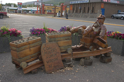
Spent last night in Chetwynd, Chain Saw Sculpture Capitol of the World. This is the largest town we had seen since Whitehorse. About 2600 folks.
Wood sculptures were all over the town.


The drive down to Prince George was slow and wet.  Lots of escorted construction through muddy, slippery areas.  Saw some mountains being systematically dismantled for coal mining – the highway forms a boundary with the largest coal deposits in North America. At 80,000 people, Prince George is the biggest town we have been in since Anchorage, but it isn’t a tourist town.  Lots of industry and not that pretty.  We were going to spend a full day here checking it out but decided to spend that extra day in Vancouver.
Will continue south tomorrow on the Caribou Highway.  This is another area where goldrushing occurred around the turn of the century.  Expect to get to Vancouver day after tomorrow.
Russ decided he needed to get some glacier water as a souvenir.